 copy")
The woods had a magical fairy-land feel, like a gnome in a jaunty top-hat might come jumping out any minute. Rising from the mossy floor were conical silver firs, stout Sitka spruce, and towering Douglas firs, all filtering sunlight into wispy beams. I wandered through the inviting forest, probably the first person to walk there in ten or a hundred years, or maybe ever.
This is what I had come for, really, to travel through forest primeval, get swallowed by a dank deep wilderscape of moss and water and fern and big big trees, a place where I’d sooner come across a sasquatch than another person. The Bogachiel Valley of the Olympic Peninsula fit the bill, and the fact that record silver fir trees lurked there secured interest from American Forests magazine. A primary mission of the trip would be to survey for champion specimens of silver fir—Abies amabilis. Additionally, my route would follow the Bogachiel River from its source to the Pacific, as part of my Source to Sea Project. Traveling by foot and pack raft, I hoped to immerse into a land that few humans have ever seen.
The isolation of the Bogachiel was reinforced before I even reached the watershed, when a park ranger told me of a German man who had disappeared en route to the more popular Hoh River about a decade ago. Vanished, gone, dissolved, digested by this beautiful gnarly wilderness that holds ten million nooks capable of the deed. Supposition has it that he dropped into the Bogachiel Basin thinking it was the Hoh, and, being winter, he had little chance of emerging alive. “Keep an eye out for any sign of him,” she suggested as I rambled up the trail.
 copy")
Macabre visions of perished hikers drifted away as I caught my first glimpse of the wild Bogachiel, where a distant black bear rambled across a snowfield at the river’s headwaters. I strolled above the river canyon lost in high country idyll—wildflowers of purple and yellow and white, mountainsides painted Kelly green and streaked with bright white shocks of snow, bewitching hemlocks swooping over rumbling river valleys, and high peaks rising above it all, their jagged black spires poking out of white and blue glaciers that hung precariously, overburdened with volumes of snow.

The beauty was thrilling, but the nights were cold and the mosquitoes thick near treeline, so I followed one of Olympic National Park’s exhaustively maintained trails to a ridge saddle where I dropped into the forest, stepping into the unknown. The terrain was ridiculously steep, but dense vegetation offered hand holds with which I could slow my descent. I veered into the towering timber, one hand on a huckleberry bush or small tree, the other stabbing my paddle into the duff, I shuffled my feet downward, edging into the slope as if I were side-slipping with skis.
 copy")
My first sight of the river elicited elation. My second, more thorough view brought disappointment. The creek, less than knee deep, splintered into three channels and poured over small boulders, spilling into a nest of bank fallen logs. There would be no boating a stream like this. But all was not lost. A good game trail followed the river, a soft sand campsite was at hand, and I was deep in the wild Bogachiel, far from the manicured camps and groups of backpackers up above. To further boost my spirits, a silver fir grew nearby—arrow straight and soaring 205-feet into the sky.

Carefully probing my way along the game trail the next day, I noticed a large trunk in the distance. I might have breezed past, but the tower of wood kept re-emerging through the cathedral forest, and finally I dropped my pack to scramble over for a closer look. Nearing the big tree, I found that it was a silver fir, and it was near record proportions.
An hour of measurements later, I set up a photo of the tree. Touching the shutter, I raced to the trunk before the 30-second camera timer expired. Starting my return, I couldn’t locate the 4-foot tall metal tripod with my camera on top. Eerie. Wandering the perimeter of a bog looking for my stuff, I soon noticed that the tree where I had spent the last hour was missing too. Exasperation, worry—dare I say panic?—began to set in. My pace quickened, scurrying over decaying moss-covered logs and squishing through the swamp where my camera waited, somewhere. With relief, I re-spotted the big tree. Back to square one. This time, I scanned carefully for my gear and found it in moments, still unsure how I had lost my direction.
Flustered from the two minutes of lost wandering, I hastily started off, jumping for a log to avoid wetting my already wet feet. The log was grease slick (as are almost all logs in a rain forest!), and I was down in an instant. My left thumb caught in my camera case handle as I landed, and I got up swearing and grabbing my digit—the same thumb that’s already a ligament down from a ski injury two years ago. Off to the river I trudged, for a hand soak and tape job to hold my parts back together. Small mistakes like this can quickly develop into life threatening scenarios this far in the backcountry. I breathed deeply, resolving to be smarter next time.

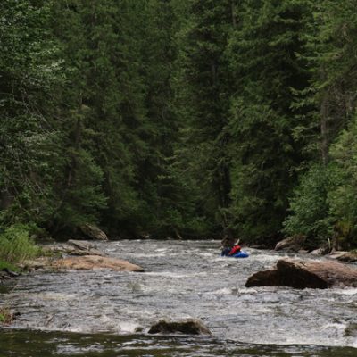
Open parks of bigleaf maple lined the river now, offering a welcome respite from the cluttered dark woods. But it didn’t last. The river trail led inland at a cutbank and splintered into a hummocky, buggy, deadfall maze beneath Sitka spruce, boggy and thick. When I reached water’s edge again, it was too appealing to resist. I blew up the boat, dry-bagged my gear, and began paddling. It was true pleasure to be floating, even if I did have to bounce and slide and push and wiggle through the rocks that were inches or less below the surface.
More boulders, a narrower riverbed, a drop that forced me to catch an eddy, changes were afoot. The river plunged ahead. I had to hustle to a stop above a falls, below which gray walls emerged, pinching the river into a dark ominous gorge. Ironically, the daunting terrain uplifted my psyche, because I knew exactly where I was. This was the falls and gorge I had pored over a dozen times on satellite photos, indicated as nothing but a dark blank gash to the cameras in space. I could have explored its depths, but whitewater wasn’t my focus on this trip, big trees were, and they grew on the flat above. In the morning, it was time to go hiking again.
Cresting a 4-foot-high moss covered root, I was stopped in my tracks by the stark incongruous color white. A clean bleached skeleton of a bull elk lay mostly intact, surrounded by a trio of fir trees. Antlers stood four feet high and dark brown, firmly attached to the skull. I snapped a few photos and sat for a minute, marveling at the great creature.
The gorge relented, revealing a corridor of alders and maples leaning out over quiet water. Time to float. The rest of the day was spent zigging and zagging and spinning and scooching, finding a way through the too shallow boulder mazes. Now and then a real drop would sluice me down a chute, water gulphing over the tubes and pouring onto the spraydeck of my pack raft.
It wasn’t long, I knew, until the river would steepen and fall precipitously into another gorge, where two falls were shown on the map, the same map that claimed the river crossed the 1,000-foot elevation contour in two different locales, once on each quadrangle. I decided it was all terra incognita, the 200-foot forest canopy too dense to allow an accurate topographic portrayal from above. Uncertain of the next day’s adventure, I journaled by my campfire that night, “I will find what I find. If the river is manageable, I float. If it is not, I walk. If the slopes are too steep, I backtrack. The animals know the way. Perhaps they will show me, if only I listen.”
An elk path carved clearly through forest deadfall near a 30-foot waterfall, the first one indicated on the map. Ah hah, the map was right this time! Again, the raft was rolled and stashed in my backpack. Two hours of old growth bushwhacking brought me to the elfin forest grove, and back to the rim of the Bogachiel gorge. I edged along the canyon, the river spilling over drops far below, precisely where my map hinted at an open flat. I could see, through a labyrinth of foliage, the North Fork of the Bogachiel entering the main stem. Still, the gorge rose. Eschewing my better judgment, I started down a steep slope of sword fern, feeling my way toward the river. At the confluence, I pumped the raft on a six by six-foot spit of gravel, rock walls and green verticality all around.
 copy")
And it stayed that way. Several steep rapids and a lovely canyon led, finally, to more open terrain a couple miles downstream, where the river fanned into a broad gravel bed. Several elk, the first I’d seen despite following their trails for days, scurried into the forest as I drifted past, kicking up a dust cloud as they burst away. Any lingering particulates were quelled that evening when the Pacific’s marine layer methodically advanced upstream. I hid from the ocean dew in my tent, its salty odor wafting through unmistakably.
The gray broke early, allowing swaths of sun to lighten the somber lid of morning. I moved slowly, trying to capture the brilliant light in photos; the cedars that stuck their bellies out over the water, the driftwood logs that lay along the river, their root balls reaching thirty feet into the air, the many shades of blue and green and gray and black indicating each successive ridgeline of trees reaching for the misty mountains.
 copy")
It was glorious old-growth floating until the bright green of a several-years-old clearcut starkly indicated the park boundary. Highway 101 bridged the river an hour later and it was time to re-adjust my psyche for the high speed distracted pace of civilization. The first driver to whom I subtly tossed my thumb came to a rapid halt and backed up onto the shoulder of highway.
He was a young bearded man driving a pickup full of greasy logging equipment. When I opened the passenger door, a young black lab stared up at me, curled in the passenger footwell. “She’s pretty mellow,” I said. “Not when she fuckin’ hears me load my bird gun,” he replied. We were in the town of Forks in seven minutes.
Once the logging Mecca, Forks is now like the retired champ, used up but far from dead. The town is making a part-time bid as a tourist hub, but with over 100 inches of annual rainfall in a region where most folks are plenty sick of the rain, the writing is on the wall. The popular book and movie series Twilight has offered a small boost to the economy of late. Featuring a teenage vampire and werewolf, the story is set here in misty Forks, drawing Twilightacolytes from across the country. Both the café and grocery store were thriving on this August day. January might be another story.

Some of the Forks tribe awoke me at first light as they tramped down the gravel beach where my tent was pitched, just below the confluence of the Calawah River. They were in search of steelhead, and despite one exciting short-lived hooking, the fish were safe on this morning. The fisherman all filed back to their day jobs, leaving me alone on the beach, standing by the warmth of their driftwood fire. Before departing, one of the older anglers chatted with me about the river, the big slow pools, the brutal headwinds, the tides. Oh yes, tides! On the Fraser River, I battled them for an entire afternoon. On the Klamath, they nearly washed my camp away while I was out for a walk. Now here I was on my fourth source to sea trip, and still I was sadly unaware of the importance of tides. The fisherman thought high tide would be at 3pm, so after that time I should be riding the ebb flow for the final few miles to the ocean. I decided to paddle for tidewater, and be prepared to wait it out.
I paddled and lolled down a forever straightaway below the confluence of the Soleduck River, which added a welcome 400 cubic feet per second, more than doubling the flow. Technically the Bogachiel below the confluence was the Quilayutte River, but geographic nomenclature was background to me now. I had a nose for the sea.

A light breeze began. The paddling became slower. Subtle changes in the riverbanks told me that I might be reaching that transition from inland river to tidal. The gravel bars were less steep. The river had softer edges, more uniform, less tempestuous. The water took on a slightly different hue. I pulled over to have a look from shore, and in mere seconds it was apparent that a tidal current was racing upstream. I waited. In the time it took to eat a few snacks, the upstream flow seemed to weaken. I stood and watched the water shift, ever so gently, from flood tide to slack, and then I re-launched, bound for the sea.
Rounding an island, the ocean came into view through a gap between sea wall and harbor shore. Even at nearly a mile away, it clearly moved with raucous power, and it was higher than I was. I paddled carefully, approaching almost timidly, with genuine respect. Sea birds squawked and flocked and swirled—gulls, pelicans, cormorants, shrikes. The harbor town of La Push was on my left. On my right, a haphazard collection of boulders were capped with driftwood. Beyond that, the sea crashed.
A gentle current pushed me to the end of the sea wall, where remnant swells pulsed into the harbor. I rounded the point, still wary of unpredictable ocean currents greater than the biggest water any river has ever dealt me. Vertically sided islands rose in a crescent around me, shielding the bay from the fury of 2,000-miles of momentum. Crashes of white indicated rocky headlands hiding between the islands that took the punch out of the break. The residual swell entered the sanctuary, lifting my tiny boat and surging us inland before dropping me fast enough to tickle a little weightless unease in my stomach. But after a few rollers passed, I felt safe, cradled. I spun slowly on the Pacific swell, as if still wrapped by the green blanket of the Bogachiel. In a way, I was, and will be forever.
 copy")
2 Responses
Anton Solovyev
Hey, I am looking for information on packrafting Bogachiel. Thinking about hiking up trail to North Fork confluence and floating to the Ocean. Any information would be great. Thanks!
funhogpress
Hey Anton,
Sounds great. There is a trail all the way to the N Fork, so should be no problem floating down from there. There are a few rapids in the first mile below that spot but they are all portageable and not too bad class III – III+ as I recall. I wrote two articles about that trip which might help with info too. One is in American Forests, and on my website under “published works.” The other was in Paddle World magazine 2012, I think. Shoot me any other specific questions you have and I’ll let you know what I know. Cheers.
-Tyler